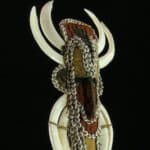
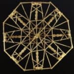
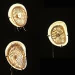
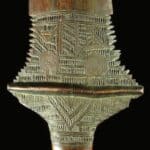
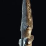
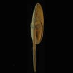
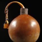
Micronesian Navigation chart wapepe
wapepe Micronesian navigation chart for sale.

Object Type: Micronesian Navigation Chart
Locality: Micronesia
Circa: 1950’s
Material: Sennit fiber, cowrie shell, and palm frond midrib
Dimensions: 43 cm
Description
A similar example is displayed at the smithsonian.
For more information about wapepe please scroll past images
Price SOLD


Wapepe Micronesian Navigation Chart
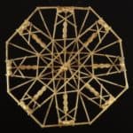
The wapepe, a small square-shaped stick chart, which shows the wave patterns that are common around all atolls.
From studying the wappepe the basic currents and wave patterns can be learned. Before sailing, the sailors know in what direction lies the new island. If they are sailing from south to north then they watch for the main currents from the east and west. Within the first few miles of leaving, the currents are watched carefully to see which one is moving faster. For example, if the current from the east is moving faster than the western current then the boat is sailed in a more north easterly direction to compensate for the pull of the easterly current.
When leaving an island, the same wave and current patterns are encountered as when approaching an island, but only the wave and current patterns of the approaching island are closely watched. For example, using the illustration, if a boat sailed from the island in the south, the boat would first encounter the jukae (first zone of currents-nearest an island), then dibukae (second zone of currents), and last jejelatae (third zone of currents – farthest away from an island).
All three of these waves together are called no in alikin bar (waves that come after the reef). As the boat proceeds north it will encounter the place where the aeto (current from the east) and aetak (current from the west) meet. At this point the boat will roll back and forth from front to back with a harder roll to the back of the boat then the front. The type of ocean at this point is called limaajnono which means choppy seas. Then the boat continues northward and the captain constantly makes sure they do not cross over the aeto (current from the east) or aetak (current from the west) which would mean they were off course.
Next the hits the aelokean (current from the north) and then is again in calmer water where the boat mainly rocks from side to side. Then the aelokrak (current from the south) is encountered.
At this point very close attention is given to the waves, for the people in the boat know they are now beginning to approach the new island although it is still very far away. The boat proceeds north and hits the place where again the aetak and aeto meet. At this point the boat rolls back and forth with the front roll of the boat being the strongest, for again the ocean is limaajnono (choppy). This signals that the island is getting close. When the jejelatae (third zone of currents) is encountered the people know they are on course and the island is nearby. Usually the island is visible by the time the dibukae (second zone of currents) is hit. Then the jukae (first zone of currents) appears and the island is very near. There is also a type of wave called dilep which the boat follows when leaving the island until arriving at the new island. All these currents can be seen and felt by experienced sailors. Many Marshallese sailors could lie in the bottom of a canoe and sail by the feel of the waves and currents. Today many of the older men and a few women can sail in this manner but since few tipnols (sailing canoe) and walaps (large sailing canoe) exist anymore, sailing between atolls is becoming rare.
*) The bulk of this section is courtesy of:
Curtis, Carol (1986) Handcrafts of the Marshall Islands. Typescript. Majuro: Museum of the Marshall Islands.


Other sold items